Phone number +233 209082061
Cote d’ivoire
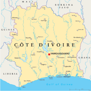 Country: Cote d Ivoire Côte d’Ivoire, country located on the coast of western Africa. The de facto capital is Abidjan; the administrative capital designate (since 1983) is Yamoussoukro.
Land
physical features of Côte d’Ivoire
Côte d’Ivoire is bounded to the north by Mali and Burkina Faso, to the east by Ghana, to the south by the Gulf of Guinea, to the southwest by Liberia, and to the northwest by Guinea.
Quick Facts
Capital: Yamoussoukro
Currency: West African CFA franc
Official Language: French
Visa Requirement: Visa Require
Climate of Côte d’Ivoire
Distribution of peoples and of rainfall in the Guinea Coast region
Equatorial and southern savanna types of climates prevail. North of approximately 8° N latitude, the southern savanna type of climate occurs, characterized by the parching wind known as the harmattan, which blows from the northeast beginning in December and ending in February. The dry season lasts from about November to March. A single rainy season from April to October produces annual precipitation totals ranging from around 45 inches (1,100 mm) in the northeast and centre to approximately 60 inches (1,500 mm) in the northwest. The northern region is drier than the rest of the country and, because of the elevation, somewhat cooler. South of 8° N latitude, two rainy seasons occur, and three climatic subdivisions may be discerned. Rain falls largely from May through July and to a lesser extent in October and November on the coastal fringe. Abidjan receives approximately 75 inches (1,900 mm) of precipitation annually, although considerable variations are experienced at different places along the coast. Average monthly temperature variation is small, and diurnal temperatures range from around the low 70s F (low 20s C) to the low 90s F (mid-30s C). In the forest zones and in the southern part of the savanna region, the rainy seasons are less pronounced. Diurnal temperatures vary between around the low 60s and low 100s F (mid-10s and upper 30s C), and the relative humidity is often high. On the mountains farther west there is no dry season, and precipitation amounts to about 80 inches (2,000 mm).
Relief
Mount Nimba Mount Nimba, the highest peak of the Nimba Range, which extends along the Guinea–Côte d’Ivoire–Liberia border in western Africa.(more)
The ground rises constantly as it recedes from the coast, and the northern half of the country consists of high savanna lying mostly 1,000 feet (300 metres) above sea level. Most of the western border with Liberia and Guinea is shaped by mountain ranges, whose highest point, Mount Nimba (5,748 feet [1,752 metres]; see also Nimba Range), is situated in the Mount Nimba Strict Nature Reserve (designated a UNESCO World Heritage site in 1982), where the borders of the three countries meet.
The country is made up of four natural regions. The coastal fringe consists of a strip of land, no more than 40 miles (64 km) wide, studded with lagoons on its eastern half. Access from the sea is made difficult by the surf and by a long submarine sandbar. Behind the coastal fringe lies the equatorial forest zone that until a century ago formed a continuous area more than 125 miles (200 km) wide. It has now been reduced to an area roughly triangular in shape, with the apex lying a little to the north of Abidjan and with the base lying along the Liberian border. The cultivated forest zone, which lies to the east of this triangle, consists of forest land that has been partially cleared for plantations, especially along the Ghana border and in the area around Bouaké. The fourth region, the northern savanna, consists of a sparsely populated plateau, offering open ground favourable for stock breeding. About 4,500 square miles (11,650 square km) in this region have been set aside to form Komoé National Park, which was designated a UNESCO World Heritage site in 1983.